Hiking Trolltunga, Norway
It was 0815, and I was lying in a hostel in Bergen, Norway, five days into a September road trip. It was a tiny room of four, the rain was pounding on the skylight, and unique odours were wafting up from the bunks below. Not just regular pedestrian hostel fare of stale booze and socks: these stale socks were something to behold. They belonged to a German man who had been traveling around by bike for 3 weeks – but with all that scenery he had found little time to do laundry – and it was making me feel like a hot shower and my own bed back in Oslo.
That was just one of the angles I was using to talk myself out of hiking Trolltunga.
Aside from the exhaustion that results from sleeping in foreign beds with strangers present (and not in a good way), I was worried that I was poorly equipped, did not have a room booked, and was lacking the fitness levels required. All of these doubts were with good foundation. "Trolltunga" (Norwegian for "The Troll’s Tongue”) is located in the Hordaland county of Norway and has been deemed “The Scariest Instagram spot on Earth” by The Huffington Post. Since the age of social media, the amount of people that taking upon the 22km hike (11 km each way) has increased from five hundred a year into the thousands. Not once has it been described as anything less than difficult.
My inner voices jousted for a good hour, but as they both had valid points, the end result was a well fought draw. We agreed with myself to go by the hiking store, ask a few questions, then get the ferry through The Hardanger Fjord to Rosendal, then jump on the 900 bus to Odda which goes along the a branch of Hardanger), the largest base for the hike, and take it from there. I was becoming about as blasé about fjords as I was about Churches in Italy: seen one, seen em all (that was The Troll’s Tongue in cheek by the way).
First stop was the hiking store. I was very close to buying some hiking boots, but was reluctant, as walking with brand new hiking boots could be problematic. I asked the “salesman” whether people hiked up in the shoes I was wearing (Solomon Cross trainers with spikes), and he said they were very common. Then I asked him about lycra leggings with some shell hiking pants, and a fleece with a Haglof's Parka. He seemed to think I was perfectly well equipped, especially after I informed him of my intense daily fitness regime of being a waitress. He told me twelve year old Norwegian kids did this shit for breakfast, and I was like, “Screw you, you blonde, beautiful, fit people. You all look the same to me”.
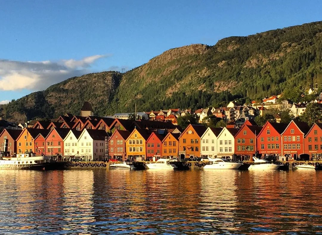
The Bergen Wharf, the starting point for my hike.

Houses on the fjord... People being alone. Together.
So off I set to the picturesque Bergen Wharf (which happens to be a world heritage site) to get a ferry to take me through Hardanger Fjord, the second longest fjord in Norway. Getting off the ferry were a group of impossibly fit Norwegian girls, wearing the same sneakers as me, I gave myself a smirk and a physical high five for my footwear selection, and started thinking that this was going to be ok (and I also got a whole row to myself on the ferry because of that enthusiastic self high five). I bought my ticket on board, but due to the earlier internal deliberations I had had no time for brekky and a coffee, so I shelled out the requisite fifteen euro for a stale sandwich and filter coffee (I had to ask for milk and sugar as that is not how Norwegians drink it). The scenery was standard (by Norway’s “Once in a Lifetime standards”), but I was particularly taken by the villages on the Fjords. I once heard comedian Arj Barker say that he wanted to buy a whole lot of hermit crabs and make them live together, and that is what Norwegian Fjord villages are like. People, being isolated. Together.

The view from the boat.
After the boat ride, I stopped in a village called Rosendal before getting a bus to Odda which took 35 minutes. I was the only person on the bus, and the driver was playing German Folk music. For a second, I was confused as to where I was, but it was a moment. As a solo traveler the pinnacle of quiet time is on a bus, entirely alone, sucking up the scenery, on the road to a challenge. I would love to attempt to describe it, but pictures from the bus window should suffice.

Taken from the bus window. This is the Sørfjorden, a branch of the Hardanger Fjord.

When I arrived in Odda, two of my travelling companions from earlier in the week were waiting. Two lovely, sweet, mid-twenties Belgian guys and after seeing them my doubts were gone. They said, “The last thing we wanted to do before we left was have a beer with you”. I wasn’t so alone with my thoughts anymore, which was a pleasant change.

The town of Odda.
“Do you think I can do this”? I asked as animated hikers ate pizzas and reflected around me. They had no need to answer, as I knew I wanted to feel like these people tomorrow. Then they verbally guided me through the hike, told me what to look out for, when to stress, and, ultimately, assured me I could do it. As I put them on the bus with heartfelt hugs, the sun disappeared.
Next was grocery shopping, as there are no “snack bars” along the way (you are kidding right), and it is 22km of hard work, I went a smidgen overboard with my packed lunch thing, buying a whole chicken, two loaves of bread, yoghurt, eggs, salami, cheese, mayonnaise, chocolate, and cookies. To name half of it. I then got a taxi to the apartment which I had found when I arrived. There had been little stress, as I simply went into the tourist office, found a place that suited me, called a number, the lady gave me a code for an apartment in Tyssedal (which is closer to where the hike begins than Odda), told me I was welcome for the few nights and to just leave the money on the table when I was done. Very trusting: don’t think that she even asked my name. I was somewhat inclined to inform her that I was Australian and that we had a tendency to be marginal, but I refrained.
I think the sun had just risen when I woke up, but I wanted to get the first bus just after 730am, so that I could begin my hike by 0800. The boys had told me that it had taken them four hours up, two hours up there and three hours back. So I conservatively guessed I would need five up and five back, with three at the top to catch my breath. They had also told me that the first and last section of the hike were the hardest. There used to be a funicular taking you up the initial steep incline, but only the remnants exist there now, just to mock you.
So off I powered, all gumption and focus. I had no map or compass, nor was I part of a tour as I had been informed that none of the above were required. Not only did you have a constant stream of people to guide your way, but there were red arrows what seemed like every ten meters. Nearing the top of the first section I started chatting to an American scientist from Pasedina (no, not Leonard or Sheldon), and with an unspoken agreement we became buddies for the day.
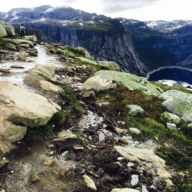
The hike had a total altitude gain of 900 meters, much of which happened in the first one and a half kilometres, but by no means was the rest easy, and I was constantly aware that I would be coming back the same way. I went through glacial potholes, sludge, snow, puddles, mud, past lakes, over sheer rocks, along ridges and a valley of rocks. Each section was distinctly different, and more powerful than the last, but all the while I was slightly distracted wondering If I was even going to walk out onto the tongue, and if I did what was I going to do? There was not a chance that I was going to sit on the edge. Ever.


I rarely stopped (more training from waitressing as I ate on the run), and we reached “The Tongue” at 1145: it was still relatively quiet so the queue to get your photo taken was only fifteen minutes, but not thirty minutes later, after I had taken my hiking buddies photo, the queue was up to an hour. Many spectated as people went out. There was cheering whilst people did yoga poses, danced the tango, cracked open a beer, held a flag or posed with their significant other, whether it be a tiny pooch or the apparent love of their life (bugger if you broke up huh)? Some people were downright stupid, getting too close to the edge without caution, and I felt that they were not taking this extraordinary nature seriously. Any other country in the world there would be someone monitoring it, and there would definitely be barriers in place, tainting the beauty.
I still hadn’t decided if I was going to go out on the tongue, after descending a ladder to the waiting area I concluded that much of it was an illusion. It was much wider than I had thought, and had a slight incline so you could not see over the edge. I strode confidently out out and lay on my back, but I was still not afraid, and decided to go and have a look over the edge for a second (with an elegant worm like approach on my stomach). I then retreated, joined my companion, approved the photos and we got ready to walk down. To be honest, even though the scenery at “The Tongue”, overlooking Lake Ringedalsvatnet was incredible, I had seen that many photos of it previously that it was the rest of the hike that had me excited, and the achievement of it all. I also gotta say, something is taken away from the serenity of hiking when the destination resembles a university mixer. Multiple outfit changes were not uncommon.

Walking back to Skjeggedal (where the hike begins) the scenery was even more dramatic. Even though it was the same landscape everything was that much more accentuated due to the rapid fading of my energy. There were hills I could not remember, sections seemed longer, and it was that much more slippery. I also noticed that I was not the only one fading. People were stopping more frequently for breaks, and there was none of the banter from earlier in the day.

With three kilometres to go I was in pain, and realised that there was no way I was going to get down quicker than I came up. My hiking buddy was still going at a fair pace, so I told him to stop waiting for me. “Go ahead without me! There is no point, I am not going to make it. Save yourself” I said as I dabbed my brow and contemplated a cookie. Or more accurately, I didn’t want to feel any pressure to go faster as with my tired legs I needed to be more cautious. Plus, with all the traffic of the day, everything was that much more slippery and difficult.
The last section was an absolute bitch. I had thought it was bad on the way up, but the pain I was feeling, combined with the muddy ropes and the fading light cause me an hour of hell. I felt like I was in slow motion, and even when I could see the bottom I knew it was another thirty minutes.
But I made it. My first order of business was to go to the bathroom, because as a chick you cannot just whip your wing-wang out and relieve yourself. Sure, you can go behind a rock, but that was not possible the majority of the time due to the landscape. My next order of business was to take my shoes off. They had served me well, but oh, how I hated them at that moment. The feeling of taking off my trainers was akin to taking off your ski boots at the end of a long day. It felt so damn good.
Following a cold, hard earned beverage we got the bus back to Odda and went straight for pizza. After nine and a half hours outdoors diligently burning calories, the cheesy goodness of a hot pizza was almost as good as taking off my shoes, and I was no longer exhausted, but animated and proud, just like the hikers before me.